
AvyPal
Avalanche Safety iPhone App

AvyPal is an
avalanche awareness safety app for the iPhone.
The AvyPal phone app can assist backcountry travelers in identifying
potential avalanche terrain. AvyPal is a simple "see through" app that
uses the phone's camera view to let you view the terrain you are
approaching. Three different modes are available to fit the backcountry
situations you often encounter:
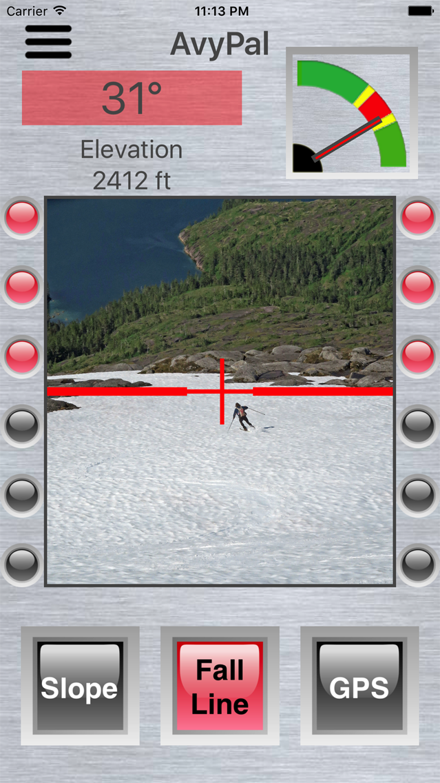
Fall Line Mode - Shows the angle and avalanche risk of a slope you
intend to descend, or ascend.
Slope Mode - Shows the angle and avalanche risk of a slope you intend to
cross.
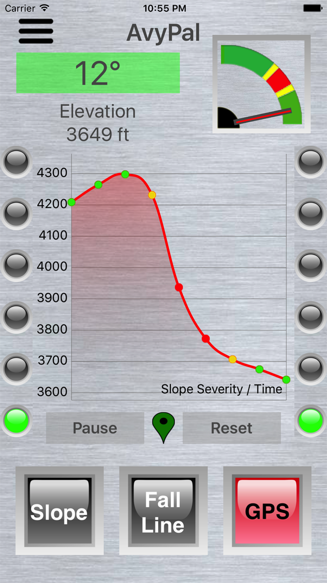
GPS Mode - Uses GPS data to audibly alert you if you are descending or
ascending a slope angle that is associated with avalanche risk. Audible
alerts are given every 5 seconds if in avalanche terrain. A graph is
also shown in the mode so you can review if you have recently traveled
in dangerous terrain.
AvyPal uses color-coded indicators to indicate the avalanche risk of
backcountry terrain. Red indicates a high probability avalanche slope
(30-45 degrees). Yellow indicates a lower probability avalanche slope
(25-30 degrees or 45-50 degrees). Green indicates slopes of less likely
avalanche potential (less than 25 degrees or greater than 50 degrees).
AvyPal is a backcountry tool for help in making route choice decisions.
AvyPal does not replace professional avalanche safety training,
experience or good judgment. Get avalanche awareness and safety
training before traveling in the backcountry.
Have fun in the backcountry. And if you have a question about the safety
of the snow slope ahead ... don't hesitate to ask your AvyPal for
advice!


AvyPal
Help.
General:
All AvyPal indicators, the angle text box, the
inclinometer, the LED arrays and the GPS graph markers, follow the same
coloring convention that is driven by the slope being measured. The
convention is as follows:
Red - Dangerous avalanche slope (between 30 and 50 degrees).
Yellow - Moderately dangerous avalanche slope (between 25 and 30 degrees
or between 45 and 50 degrees).
Green - Low
probability of a large avalanche (slope less than 25 degrees or greater
than 50 degrees).
Note: These avalanche slope metrics are based on US
Forest Service avalanche safety charts.
Sounds:
Single ping (when in GPS Mode) - in yellow avalanche warning zone.
Double ping (when in GPS Mode) - in red avalanche danger zone.
High pitched blip - GPS signal found.
Lower pitched blip - GPS signal lost.
Explanation of
mode buttons:
Slope:
This AvyPal function can be used for crossing
slopes perpendicularly. Hold the phone up so that the red and yellow
lines are aligned. Then rotate the phone to the left or right until the
red 'Slope' line is aligned with the terrain. You can also use the top
of the phone as a 'straight edge' and align it with the terrain slope.
Once the phone is tilted to the desired position, the angle text will be
shown, the inclinometer needle will show the angle and the LEDs will
indicate the slope severity. This function can also be used to judge the
angle of distant slopes.
Fall Line:
Use this mode to gage the slope
you are climbing or descending on the fall line. Point the phone uphill
or downhill and sight the red crosshairs to an object that is the same
height off the snow as your phone.
GPS:
GPS mode can be used to
monitor the slope you are on while you are skiing. GPS mode is only
effective when used while traveling on the fall line. Every 5 seconds
the angle of the slope you have been on will be calculated from GPS
altitude and distance changes. If AvyPal detects that you are on a
dangerous slope, it will beep once if you are in the yellow zone, twice
if you are in the red zone (see above for descriptions of color
convention). In addition, the GPS slope information will be saved and
charted. The GPS chart shows the angle severity of the slope you were on
every 5 seconds for up to the last 30 minutes. On the chart, the color
of the markers reflect the normal, warning and danger color coding
conventions (explained above). A black marker indicates no GPS service
is available. The Reset button clears all recorded GPS history. The
Pause button pauses the charting of data, so that you can use finger
gestures to scroll back over historical GPS slope angle data. Take the
chart off Pause and normal charting will resume.
GPS Mode Pin Icons:
Green - Good GPS signal.
White - Poor GPS signal.
Black - No GPS signal
Settings:
Choose meters or feet as units of elevation.
Turn on or off the GPS warning beeps.
If GPS warning beeps are enabled (see above), then setting this
feature allows GPS-determined slope angle beeps to occur in all modes.
This is a good option to set so that when your phone is stored in a
pocket or pack, the GPS beeps don't stop because a mode button was
bumped and the mode changed out of GPS mode.
Miscellaneous:
When
the GPS mode button is selected, a long press can be made on the Reset
button (press until the button text says 'Simulate'). This will put GPS
charing into simulation mode. Simulated slope changes will be charted so
you can see how the chart works and hear the warning beeps.
Limitations:
GPS
latitude and longitude are usually more accurate than elevation. So,
there may be spurious data when the GPS locks to different satellites. A
technique called Kalman filtering is used to smooth out erratic GPS
readings.
If AvyPal is running in the background and the screen saver comes on, GPS sounds and tracking will stop. To keep the app active, it should be run in the foreground.
The sound of your phone may be muffled by clothing. Consider using earphones or an external Bluetooth speaker in order to hear GPS Mode warning sounds.
